The Songhua River is the third largest river in China in terms of discharge and the largest tributary of the Amur River. The entire drainage basin is ca. 557000 km2 with an average discharge of 2420 m3/s. It has two sources, i.e. the Nenjiang and the Second Songhua River originated from north and south mountains respectively.
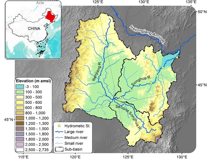
The Songhua River is the third largest river in China in terms of discharge and the largest tributary of the Amur River. The surface area of the entire drainage basin is ca. 557000 km2 with an average discharge of ca. 2420 m3/s. It has two sources, i.e. the Nenjiang and the Second Songhua River originated from north and south mountains respectively (Figure 1).

Figure 1. Map of the river system in the Songhua River basin, Northeast China.
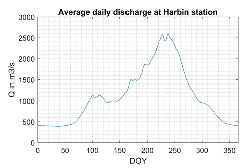
The flow regime is mainly driven by rainfall in the warm season and by snow melt and rainfall in cold season. As shown in Figure 2, there are two flow peaks in April and August due to the snow melt and intensive summer rainfall.

Figure 2. Flow regime at Harbin hydrological station (average daily discharge during 2007 - 2014)
The extreme flatness of the downstream has caused the river to meander widely and thus it is surrounded by a wide plain. Flood forecasting has been a focus in this river basin given that many cities, such as Harbin, Tonghe, Jiamusi, Fujin, etc. are along the river. Because of the topography and intensive rainfall in summer, there are many severe floods occurred during the last century, and recent decade. Figure 3 shows the flood occurred in 2013, which caused more than 20 deaths.

Figure 3. Flood of 2013 in the Songhua River captured by satellite imagery.
In this project, we are going to develop a forecasting system based on EO data and MIKE Hydro River model.

Figure 4. Flowchart of flood forecasting system